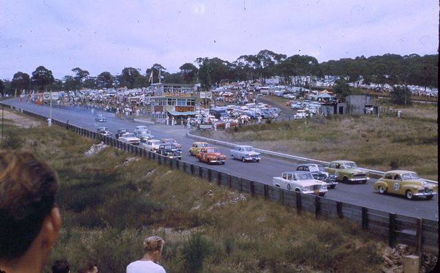
Catalina Park is a disused motor racing venue, located at Katoomba, in the Blue Mountains, and is recognised as an Aboriginal Place due to the long association of the local Gundungarra and Darug clans to the area.
Overview
The 2.1 km circuit opened on 12 February 1961. Race meetings were staged by the Australian Racing Drivers Club in association with the Blue Mountains Sporting Drivers Club through to 1969, at which time the ARDC took over the Amaroo Park circuit. A race meeting was organized by the BMSDC in January 1970, however the club went into liquidation the following year. At the time of the circuit’s closure, the lap record was credited to Frank Matich (Matich SR4) at 53.4 seconds, an average lap speed of 141 km/h.
Originally used for top level motorsport including touring car, open wheeler, motorcycle and sidecar racing in the 1960s. The mountain location caused problems with fog causing delays in the race programs, also the track was very narrow by today’s standards and surrounded by walls, armco railings and hillside. The track became used less with the opening of other circuits nearer to Sydney such as Oran Park and Amaroo Park.
In the 1970s the circuit was used for Rallycross, where the cars would use half the bitumen track and a dirt infield section with jumps, like Motocross.
By the 1980s the track was only being used for lap dashes with single cars on track at one time and was used until the mid-1990s for this.
The circuit still exists and can be walked around however it has deteriorated quite badly with grass growing through the track surface on what was Lockheed Straight and Dunlop Corner, and water seepage has caused part of the track to collapse between Craven A corner and Castrol corner.
History
Catalina Park commonly known as The Gully is a beautiful piece of land situated in Katoomba and is also known as the Katoomba Falls Creek Valley. The Gully forms the headwaters of the Katoomba Falls Creek and is therefore part of the Warragamba Catchment area that provides Sydney’s water. It is an ecologically and culturally sensitive place.
Before white settlement the Traditional Owners of the Gully – the Gundungurra and Darug peoples – used the Gully as a summer camp. Settlement at the foot of the mountains forced many Gundungurra and Darug people to resettle permanently in the Gully well before 1950. The flooding of the Burragorang Valley in the 1950s made this process irreversible.
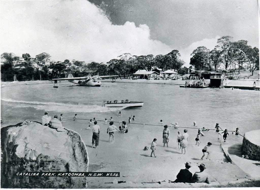
In 1946, their relatively peaceful co-existence was shattered when the area was developed as a tourist park. The Kedumba Creek which feeds to the Katoomba Falls was dammed, forming an ornamental lake. The shell of a Catalina PBY-5 flying boat was shipped up on a truck and installed in the middle of the lake, giving the area its informal name. People could pay to visit and play with the airplane controls, while speedboat rides were carried out around it. Tearooms, a miniature train, Ferris wheel, a merry-go-round, swimming pool, as well as a small cinema.[5]
Eventually the amusements park became dilapidated and unpopular, with the government buying the land in 1952. The Catalina was removed and eventually sold for scrap, and a treated swimming pool was built. five years later, a racetrack was organised by a group of 83 local businessmen (the Blue Mountains Sporting Drivers Club Limited) who were supported by the then Blue Mountains City Council. The last traditional owners were forcibly removed by 1959, The trauma caused to the land and to the community of people who were living in and around the Gully was profound – and still reverberates.
The Gully was declared an Aboriginal Place on 18 May 2002. From the time it was nominated until its declaration as an Aboriginal Place, took only nine months. The Gully in Katoomba became the largest Aboriginal Place in NSW. The Aboriginal Place declaration was warmly welcomed by the Gundungurra and Darug Traditional Owners and was marked by Indigenous and non-Indigenous alike with an official celebration in November 2002.
Under section 84 of the National Parks and Wildlife Act 1974 (NSW) (“the Act”), an Aboriginal Place declaration recognises the cultural attachment Aboriginal people have to land. Section 85 provides a mechanism for the New South Wales Government to provide appropriate protection to ensure the area is neither damaged nor destroyed. In this case, the legislation requires the landholder (the Blue Mountains City Council together with the NSW Department of Lands) acting with the Gully Traditional Owners, to protect the Indigenous heritage of the area.
Under section 90 of the Act, permission from the Aboriginal people of knowledge of the area is required before the landholder can disturb or destroy the cultural significance of the Aboriginal Place. What this has meant in practice is that local councils that are landholders have set up mechanisms of consultation with the Aboriginal people of knowledge of the area. The Gully Traditional Owners do not see this system as fulfilling the requirements of the Act. They have asked BMCC for a system of co-management.
Although there is nothing yet in the annals of the Mountains City Council and no signage on the ground to act as proof, the fact is that since 2002, a significant amount of goodwill has slowly built up in Katoomba. Several small victories have taken place in the symbolic field. Amongst the most significant of these is the documentation of the history of the Gundungurra and Darug peoples in a new book whose publication was supported by both the Sydney Catchment Authority and the Australian Centre for Independent Journalism (‘ACIJ’) at the University of Technology, Sydney. Sacred Waters: The Story of the Blue Mountains Gully Traditional Owners has been written in close collaboration with the Gully people by Blue Mountains resident for 20 years anthropologist Dr Dianne Johnson.


